New supercomputing-enabled model offers fresh hope, but climate clock keeps ticking

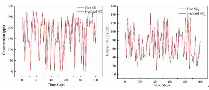
A research team led by Hefei Institutes of Physical Science in China has unveiled a new deep-learning model that significantly improves the forecasting of roadside air pollutants. The model, called DSTMA-BLSTM (Dynamic Shared and Task-specific Multi-head Attention Bidirectional Long Short-Term Memory), achieved an R² above 0.94 on major pollutants and cut prediction errors by about 30% compared with conventional LSTM models.
 
The core innovation lies in how it decomposes the intertwined effects of traffic behavior, meteorology, and emissions: a shared “attention” layer extracts common temporal patterns across pollutants, while task-specific attention heads isolate the unique dynamics of each pollutant.
 
From a supercomputing and big-data standpoint, this matters: urban air pollution is a high-dimensional, non-linear system, subject to rapid shifts in traffic flows, weather, emission regimes, and chemical transformations. Taming this complexity requires serious computing power (for training these deep models) and real-time model inference that can integrate streaming sensor data, traffic flow telemetry, meteorological forecasts, and emissions inventories.
 
In other words, we are entering an era where supercomputing-class workflows (massive data, advanced AI architectures, real-time inference) are not just for cosmology or physics; they’re now essential for everyday environmental management.

Why the urgency? And why the timing is glaring

A high-accuracy pollutant forecasting system is not confined to the lab. In an era of accelerating climate change, urbanization, and increasing regulatory pressure, the ability to predict pollutant spikes (such as traffic-related NO₂, PM₂.₅, and ozone precursors) has direct implications for public health, energy-use strategies, and climate policy.
 
However, we are at a precarious point. The COP30 climate summit in Belém, Brazil (Nov 10-21, 2025), saw world leaders state clearly that the planet has already exceeded the 1.5 °C threshold above pre-industrial levels, a critical point for habitability. The summit agenda focuses not only on mitigation (reducing emissions) but also on adaptation, resilience, and science-based decision-making.
 
This directly relates to the Hefei team's work: one enabler of adaptation is improved forecasting of environmental hazards (including air quality), made possible by computing power and AI. If cities can anticipate problems sooner, they can respond more quickly.
 
But here’s the catch:
  • Better forecasting is necessary, but not sufficient: You can predict pollutant spikes, but if the infrastructure, policies, or finance to act are missing, forecasting becomes an academic exercise.
  • The compute-intensive nature of such models means only organizations with high-performance infrastructure or dedicated cloud investments can deploy them, raising concerns about inequality across cities and nations.
  • At COP30, despite abundant promises, a significant gap persists. According to policy analysts, current national plans (NDCs) still place the world on a warming trajectory of 2.3-2.8 °C, well exceeding the 1.5 °C target.
  • Brazil’s hosting of COP30 is symbolically powerful; the Amazon region is central to global climate dynamics, yet the infrastructure demands of such a summit (and the larger transition) place additional pressure on ecosystems and resources.

What this means for cities

For any firms working at the intersection of big data, real estate, and predictive systems, here’s the play:
  • Integrate supercomputing-grade forecasting models into urban-scale platforms (e.g., neighborhood-level pollutant alerts, real estate risk dashboards, development-planning tools).
  • Recognize that climate risk is now ambient: air-quality shocks, energy-use surges, and infrastructure strain all feed into property value, tenant demand, and regulatory exposure.
  • Position real-estate intelligence tools to reflect the new era: not just “location, condition, comps” but “real-time environmental intelligence, resilience capacity, compute-enabled forecasts”.
  • Advocate for compute equity: if only select cities can afford real-time supercomputing models, the climate justice gap widens. Platforms that democratize access become strategic.

Bottom line

The Hefei team’s advance is a hopeful sign: supercomputing and AI are proving to be potent levers in environmental forecasting and management. But the larger picture remains sobering: at COP30, the world was warned we are already beyond critical thresholds, and cities face accelerating hazards. The compute muscle is necessary now; it must be matched by policy, infrastructure, equity, and action.
 
If we don’t build the “compute infrastructure for resilience” alongside our climate infrastructure, forecasts risk becoming unused tools in a climate-stressed world. Let’s keep these worlds, supercomputing, urban resilience, and climate policy tightly coupled.

Antarctica’s cry, and the supercomputer answers: a grim forecast

In research resembling a cosmic warning, scientists at the University of Rhode Island (URI) and collaborators used advanced supercomputing to simulate how the melting Antarctic Ice Sheet will reshape our climate and coastlines over the next two centuries. The results are sobering. Dr. Ambarish Karmalkar, assistant professor in URI’s Department of Geosciences and co-author of the study, helped design and run simulations that integrate the ice sheet, ocean, and atmosphere simultaneously.
 
“Simulating ice-sheet–climate interactions … is challenging but critical,” he says. Supercomputing is proving to be the heavy lifter of climate truths. To gain meaningful insight into complex systems like Antarctica’s ice and the global climate, the team relied on high-end supercomputing resources. In their experiment, they ran interactive models on a supercomputer that allowed the meltwater discharge from Antarctica to dynamically affect oceans and atmosphere, rather than just being included as a simple input.

Why does this matter? 

Previous models, lacking real-time feedback from the ice sheet, painted an overly optimistic picture. However, when we fully couple the ice, ocean, and atmosphere, we uncover hidden risks: uneven sea level rise, particularly in the Pacific, Indian Ocean, and Caribbean; unexpected warming in regions far from Antarctica, such as eastern North America; and complex, counter-intuitive dynamics where meltwater cools the Southern Hemisphere but warms the Northern Hemisphere. In short, the supercomputer didn't just predict global sea level rise; it revealed where, how fast, and how unevenly it will occur.

The Forecast: One to Three Meters by 2200, Unless We Act

Under a “very high emissions” scenario, the melting Antarctic sheet alone could contribute over 3 meters (10 feet) of global sea level rise by the year 2200. Under a more moderate scenario, it’s still ~1 meter (3 feet).
 
Meanwhile, some low-lying islands and coastal regions in the Pacific, Indian, and Caribbean zones could see regional rises of up to 1.5 meters (5 feet) due to gravitational and Earth-deformation effects.
 
These are not distant problems. By 2060, more than one billion people will live in low-elevation coastal zones already vulnerable today to storms, erosion, and surge.
 
And the ripple effects from major sea-level rise reach inland: migration pressures, infrastructure costs, economic shifts, all rippling waves.

The Takeaway

The team at URI used cutting-edge supercomputing to reveal a harder truth: melting Antarctica isn't a far-off apocalypse; it's an unfolding structural change with winners, losers, and vast uncertainties. The models show a world where your location and speed of action make a difference. Shrugging won't help. Investing in "knowing the future" via data, modeling, narratives, tools will.

Beam me up: From Earth to orbit; Aussie scientists unlock new quantum leap

The frontier of quantum communication just flipped; instead of just downlinking from space to Earth, scientists at the University of Technology Sydney (UTS) say we’re now beaming up. A new study reveals it’s feasible to send quantum-entangled particles from Earth up to satellites, a reversal of the usual satellite-to-ground model.
 
Here’s what’s going on and why it matters.

What did they do?

In the study titled “Quantum entanglement distribution via uplink satellite channels,” led by Simon Devitt and Alexander Solntsev, the UTS team ran detailed modeling of the Earth-to-space path of entangled photons. They accounted for real-world complications, including atmospheric scattering, moonlight reflections, ground station optics misalignment, and satellites moving at approximately 20,000 km/h, around 500 km above Earth.
 
Until now, quantum satellites primarily created entangled photon pairs on board and then sent one photon to each of two ground stations (a “downlink” model). The UTS team proposes instead that two ground stations emit entangled photons upward simultaneously to a satellite, where they meet and interfere properly, thus maintaining entanglement.
 
Their findings indicate that this approach is feasible.
 
The uplink path, which had previously been dismissed as too lossy or noisy, can be engineered to function effectively.

Why does this matter?

  • More power on the ground. Ground stations can host stronger photon sources, better maintenance, upgrades satellites are constrained by size/weight/power. Uplink shifts the heavy lifting downward.
  • Higher bandwidth for a quantum internet. The team suggests that for building a true quantum internet (rather than just ultra-secure keys), you need many photons and strong links. Uplink helps enable that.
  • Cost and scalability. Satellites become simpler: instead of needing bulky quantum-hardware, they may only need a compact optical unit to detect interference. That lowers cost and increases scalability.

What about China & global context?

Yes, China has been a leader in quantum satellite communications. Back in 2016, they launched the Micius satellite, the first to demonstrate space-based quantum key distribution. More recently (2025), a Chinese micro-satellite (Jinan-1) achieved a 12,900 km quantum link between China and South Africa.
 
So, UTS isn’t starting from scratch, but they are innovating the direction of the link (uplink vs downlink). It shows the global quantum race is maturing: China has the early wins, but Australia and other players are pushing the next phases.

What’s next & caveats

The research is currently based on modeling, not full-space experiments. While simulating the uplink channel is one thing, real-mission conditions present challenges such as atmospheric turbulence, moving satellites, and alignment drift. UTS suggests near-term experiments using balloons or drones.
 
Furthermore, transitioning from quantum key distribution (QKD), which focuses on secure key sharing, to a full quantum internet, involving quantum computers and sensing, presents numerous engineering hurdles. Uplink technology is just one piece of this complex puzzle.

Bottom line

This development is a significant shift. The idea of firing quantum signals up to space opens new architectures for a quantum internet. It lowers the satellite burden and boosts ground-station capability. If experiments verify the model, the next decade could bring more scalable, global quantum networks than we thought possible.
 
And yes, China’s earlier quantum satellite milestones provide a strong foundation, but this new direction shows the field is evolving beyond “who launched the first quantum satellite” to “how do we build global quantum infrastructure.”