ACADEMIA
'PolyZoom' is new tool to view, study graphics
Researchers have created a next-generation zoom function to view and compare portions of complex graphics such as city maps, scientific images or pages of text.
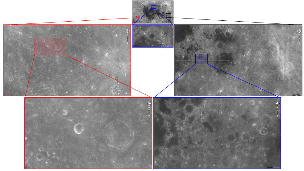
The new tool, PolyZoom, makes it possible to simultaneously magnify many parts of a graphic without losing sight of the original picture.
"With standard programs, once you zoom in you lose perspective and have to zoom out again so see that bigger picture," said Niklas Elmqvist, an assistant professor of electrical and computer engineering. "This new tool maintains your perspective or orientation."
The zoomed-in regions appear as separate pullout boxes displayed next to each other. These boxes, or "correlated graphics," allow the user to see where the magnified viewpoints are located in relation to each other and the whole.
"The tool is useful if you are trying to compare different spaces on a map, like the city centers of two major metropolitan areas, segments of a Hubble Space Telescope picture or even pages in a lengthy document," said Elmqvist, who is working with doctoral students Waqas Javed and Sohaib Ghani. "Say you are a historian looking at a large collection of scanned pages from a book. You might want to zoom into a particular page and read the words, or look at many pages at the same time and compare those.
The researchers tested PolyZoom in two user studies, comparing it with standard navigation techniques.
"We wanted to make sure that using PolyZoom doesn't slow people down and that it is as fast as or faster than navigating with a normal Web browser," Elmqvist said. "In both user studies we found that people were faster using our technique compared to existing products. It provides new ways of viewing several parts of a map at once, for example, which you currently can't do with existing products."
Findings will be detailed in a paper being presented during the Association for Computing Machinery's CHI 2012 conference on May 5-10 in Austin, Texas. (The research paper is available at https://engineering.purdue.edu/~elm/projects/polyzoom/polyzoom.pdf)
The tool is designed for users navigating "multiscale visual space."
"The fact that you can keep zooming in, continually showing more and more detail, is what we call multiscale visual space," Elmqvist said. "The most common techniques for navigating in multiscale visual spaces are pan, zoom, and bird's eye views. However, these techniques are often tedious and cumbersome to use, especially when objects of interest are located far apart."
The tool allows segments to be color-coded for ease of comparison.
The researchers built a demo that works in conjunction with Google Maps, available at http://web.ics.purdue.edu/~wjaved/projects/stackZoom
"Our implementation is standalone, but the demonstration can be run in any Web browser," Elmqvist said. "However, it is certainly possible to incorporate this into an existing program such as Google Maps, GIS and GPS software."


 How to resolve AdBlock issue?