ACADEMIA
Chinese researchers put satellite cloud image forecasting into operation

Cloud is a tracer for a variety of significant weather changes. Cloud images obtained from satellite remote sensing are of great help to weather forecasters in understanding the past and present weather processes in a macroscopic way. Forecasts directly made out of satellite cloud images are what meteorologists and forecasters dream about. Recent studies have shown that it has become possible to produce satellite cloud image forecasts for the next few, dozens, or even tens of hours.
{module In-article}
A research paper authored by Shi Xiaokang, Li Yaodong, Liu Jianwen, Xiang Xizi, and Liu Le, who are from Beijing Aviation Meteorological Institute, presents the making method for simulating FY-2D infrared cloud images, and analyzes in detail the effects of simulation errors in WRF regional numerical weather cloud parameters on the simulation accuracy of brightness temperature of FY-2D infrared channel.
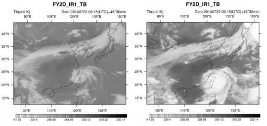
Adopting the high-resolution WRF regional numerical weather prediction model products and the forward radiation transfer model RTTOV, the five researchers have made an attempt of simulating infrared channel brightness temperature of geostationary meteorological satellite, and, meanwhile, compared it with the actual satellite cloud images.
The results show that the correlation coefficients of simulated and observed brightness temperatures of the four infrared channels are all greater than 0.5 in 0-24 hours, and the root mean square error (RMSE) of each channel is controlled at 10-27 K, which is better than that of the previous research result of 20-40K. Seen from the images, the distribution pattern and structure of the weather system reflected by the predicted cloud image have a high similarity with the actual satellite cloud image, which can provide a certain reference for forecasting the weather.
The success or failure of the cloud image forecast mainly depends on two factors: one is the accuracy of numerical weather forecast and the other is the rationality of radiation transfer model. The most critical for the former is the atmospheric temperature and humidity structure of model and the precision and accuracy of macro- and micro-scale process predictions of clouds, while the latter focuses on the accurate description of different atmospheric structures, especially cloud and rain weather processes, by the radiation transfer model.
The emphasis of this research is put on the simulation and effect verification of the sensitivity of the current general fast radiation transfer model to the numerical model cloud macro and micro prediction products. The results show that improving the forecasting ability of model to clouds and the adaptability of the radiation transfer model to different cloud processes will be an important direction for future research.
The ever-changing clouds make it difficult to predict. The current cloud image forecast can only provide some references for the development of cloud systems with large scales and longer life cycles. However, with the advancement of technology, high-precision numerical weather forecasting ability for various types of weather processes is bound to become stronger and stronger, and the radiation transfer model will become more and more reasonable. So, the forecast of satellite cloud image which can directly reflect the macroscopic change of clouds will get more and more close to the operational application.


 How to resolve AdBlock issue?